
❐ International Desk
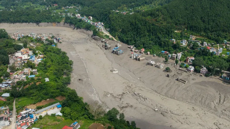
The recent flash floods that hit Nepal’s Rasua district have created a truly devastating scene. A massive flow of water, ice and rocks has caused devastation across an area of about 170 kilometers along two rivers. The area, located near the Tibetan border, was known as a popular trekking destination for tourists.
Satellite images show that many homes and infrastructure have been swept away or buried under mud and rocks. Rescue efforts have been hampered by the collapse of power and water supply systems.
Local farmland and rice fields, which were the main source of livelihood for people in the region, have been buried under thick layers of silt and debris. Nearly 400 people have been reported dead so far, and nearly 1,400 are still missing.
Helicopters have become the main means of rescue in remote areas, and with more rain forecast for the coming weekend, there are fears of fresh flooding.
The analysis shows that, based on data from satellites, drones and helicopters, scientists’ initial idea is that a section of a glacier and its adjacent mountain slope collapsed at an altitude of about 5,000 meters. This is called a “rock-ice avalanche”.
This mixture of ice and rock falls about 1,300 meters down into the valley, where the ice breaks down and turns into water. It also mixes with dead glacier ice, water pockets, debris, and large rocks that have accumulated on the valley floor, which together form a huge flow.
Initial estimates suggest the main landslide involved about 100 million cubic meters of material, but as the flow moved downstream, more ice, debris, and even houses and bridges were added to it, increasing its size.
This process of one disaster leading to another is called “cascading hazards”—much like a chain reaction.
This incident is not an isolated accident, but rather the latest addition to a familiar pattern that has been seen repeatedly in the Himalayan region over the past decade.
In 2013, more than 5,000 people lost their lives in severe floods in Uttarakhand, India. In 2021, another glacier disaster occurred in Chamoli in the same state. In 2023, a glacial lake collapse in Sikkim created a tsunami-like wave, killing 55 people.
In 2024, another deadly flood in Nepal killed 244 people. And now in 2026, another disaster struck the Nepal-Tibet border. Different countries, different rivers, different causes—but the mountains are the same.
The main reason behind this is the geological age and structure of the Himalayas. The mountains were formed by the collision of the Indian and Eurasian tectonic plates about 50 to 70 million years ago, making them geologically the “youngest” mountain range on Earth.
That conflict has not stopped even today—the mountains are still rising, the underground pressure is still active, the bedrock is still prone to cracking. As a result, earthquakes, landslides, and slope collapses are not exceptions in this region, but rather part of the natural process of nature.
Added to this is the steep, stair-like terrain—where even a small landslide can block the river’s course, causing water to pool, and if that natural dam breaks, the entire valley instantly becomes a floodplain.
The Himalayas are called the “Third Pole” because they contain the largest amount of ice and snow outside the North and South Poles—thousands of glaciers. For thousands of years, this ice has held the mountain slopes like glue, keeping the soil and rock stable.
But as temperatures rise, that natural glue is weakening—glaciers are retreating, new lakes are forming, and ice and rock are becoming unstable. This creates the risk of avalanches, like the one that recently occurred in Nepal.
Human activities are also increasing this risk. New roads, hotels, settlements, dams and hydroelectric projects are constantly being built in mountainous regions. But the mountains do not care about these development plans. Cutting down the slopes to widen the road can weaken it, and if the entire valley is filled with hotels and infrastructure, the damage from a single disaster increases manifold.
The region also attracts a large number of pilgrims and tourists—thousands of pilgrims visit pilgrimage sites like Kedarnath, Badrinath, Amarnath, Himakonda, or Mansarovar every year, as well as adventure seekers to places like Everest Base Camp or Ladakh. While this tourism is important for the local economy, it also increases risks.
It is not possible to tell people to leave the mountains, so the real challenge is to find ways to develop without increasing the risk. Earthquakes or glaciers cannot be prevented, but better warning and response systems can be developed.
It should start with better monitoring—watching high-risk glacial lakes, monitoring rainfall, monitoring landslides, using satellites and sensors, and most importantly—converting that information into real warnings that people can use.
This task cannot be done by any one country alone. The Himalayas span multiple countries, and rivers flow across borders, so floods do not respect borders.
What happens in the high mountains of China or Nepal can have an impact on the settlements of India below. When mountains do not stop at border checkpoints, information sharing should not stop either. Rapid and seamless information exchange and stronger warning systems are needed among Himalayan-adjacent countries—because seeing the same kind of disaster every year, it is no longer possible to dismiss it as a mere “unexpected accident.”
The Himalayas may remain unpredictable, but not being prepared for them should no longer be unpredictable.

https://stapravda.ru/20221228/reyting_samyh_populyarnyh_hostingov_v_rossii_196445.html, рейтинг хостингов России подтверждает, что выбор надежного провайдера важен для бизнеса.